I’ve recently started to write a mobile application (React Native) as a way to explore my concept of transients more literally. In this case, I want to capture all the sensor data that today’s cell phones provide and use it to build and store a transient in a database (Firebase/cloud) and then, in turn map them.
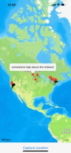
I started simply. The app keeps track of your precise space-time (via GPS) and provides one button to, anonymously, “place” a transient on a map. All of your transients then appear on map, where you placed them. You can click on a marker to see the data placed there.
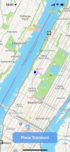

Every time a transient is “placed” a data element is stored that includes the GPS lat, lon and time data, altitude, magnetometer and, lastly, an optional note that the user can add. The note, to me, is a bit of space-time graffiti – a little reminiscent of the “Kilroy was here” meme 😉 Only text can we added to a transient marker currently but future versions will allow pictures, video, audio and other media to be stored as well.
A transient, conceptually, should include every possible sensory data point available at a specific space-time. So, this initial foray is just a tiny toe in a vast ocean of water. I will continue to add new, phone-based sensor data and explore ways to include derived and calculated data elements as well.
It’s not hard to imagine how the collected data could be applied to both creative and practical use cases. I’m looking forward to seeing how this evolves. The “doing” always helps align things better than just the “thinking”. I’ll keep sharing what I discover.

Leave a comment